 Games
About this game
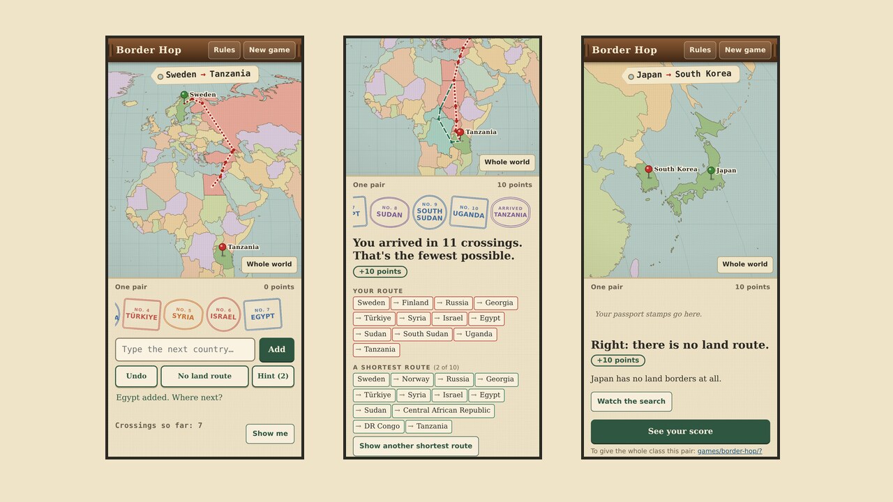
The screen looks like an old pull-down wall map. A luggage tag names two countries, and pins mark them on the map. The student types the first country they'd cross into, then the next, and so on. Each one has to share a land border with the one before. The route draws itself as a dotted red pencil line, and each country gets a passport stamp.
"Shortest" means the fewest border crossings, not the fewest kilometres. Sweden to Tanzania takes 11 crossings, for example through Finland, Russia, Georgia, Türkiye, Syria, Israel, Egypt, Sudan, South Sudan and Uganda.
When a country doesn't fit, the game says why: "Egypt doesn't border Saudi Arabia", or "Your route reaches Russia in Kaliningrad, which doesn't border Finland." Some pairs have no land route, such as Japan and South Korea. The student has to press No land route for those.
After each pair, the map shows the student's route next to a shortest one. The game says how many shortest routes there are, lists the places on them, and adds a line about any disputed border on the way. It also draws the shortest routes as a network, with countries as dots and borders as lines. Watch the search colours the map one border further out at a time until it reaches the end, which is how the game finds the answer.
The fewest crossings scores 10 points. Each extra crossing costs 2, and each hint costs 1. There are ten pairs, from 2 crossings up to 8 or more.
Easy level. For students who are still learning the map, Easy lists every country next door to where their route is, as its first letter and length: "T… 7" for Türkiye. When two neighbours start the same way, it shows another letter, such as "Ka… 10" and "Ky… 10" next to China. The list changes after every step and every Undo. It doesn't say which neighbour is on the shortest route, so students still have to plan. Points work the same, and Easy scores are kept apart from Normal ones. Add &level=easy to a link to start the class on Easy.
The rules
Which borders count is a choice, so the game shows its rules on a card. In short: a border along a river or through a lake counts. Bridges and tunnels between two countries, such as the Channel Tunnel, don't, unless you turn them on. A country's own bridges and canal crossings join its land, but open sea doesn't. A country in the middle of a route has to be crossed on one piece of its land, so Poland to Kaliningrad to mainland Russia isn't a route. Disputed borders follow who holds the ground, and the game says when a route uses one. The map decides, not whether a border is open today, so some routes cross closed borders and war zones.
Territories such as Greenland, French Guiana and Hong Kong count as places of their own. Australia recognises Palestine, Kosovo and Vatican City, so they're in the game too.
Students will
- Find countries on a world map and name their neighbours.
- Explain why some places have no land route between them, using islands, seas and pieces of countries cut off by water.
- Describe a disputed border and who holds the ground on each side.
- Model the world's land borders as a network and find a shortest path by breadth-first search.
Curriculum links
Checked against the documents below in November 2026. It covers parts of each, not whole units.
- Year 10, Australian Curriculum v9 Geography. No content description is about naming countries or borders. Use the game as a warm-up for AC9HG10S02 (collect, represent and compare data and information, using geospatial technologies and digital tools as appropriate) and AC9HG10S03 (explain patterns and trends and infer relationships), for example why the Americas have no land route to the rest of the world. Senior geography syllabuses weren't matched.
- Mathematics: networks and shortest paths. Countries are vertices and borders are edges, each with weight 1.
- Victoria, VCE General Mathematics 2023–2027: Unit 2 Graphs and networks (connected graphs, paths, the shortest path by inspection) and Unit 4 Networks and decision mathematics (shortest path, Dijkstra's algorithm).
- NSW, Mathematics Standard 2, Year 12 MS-N2 Network concepts (shortest paths).
- Queensland, QCAA General Mathematics 2025, Unit 4 Investing and networking: Topic 3 Graphs and networks, and Networks and decision mathematics.
- Australian Curriculum senior General Mathematics: Unit 3 Graphs and networks, and Unit 4 Networks and decision mathematics.
- WA, SA and Tasmania weren't checked. Look at your current syllabus before using it there.
Using it in class
- One pair for everyone. Add ?from= and ?to= to the game's address with two-letter country codes, for example games/border-hop/?from=SE&to=TZ. The summary after each pair shows its link. Add ?seed= and the game number from the end screen to give the class the same ten pairs.
- On the board (10 minutes). Put up Sweden to Tanzania. Students write a route on paper first. Take a few and count the crossings, then type the shortest one in.
- Alone or in pairs (15 to 20 minutes). Ten pairs each. Ask students to note one pair where their route was longer than the shortest, and which country they missed.
- Geography discussion. Why does no land route reach Indonesia from mainland Asia, or the Americas from Africa? Which borders on the Sweden route are disputed or closed, and what would a real traveller face?
- Maths extension. Press Watch the search and have students write down how many new countries appear at each step. Then draw a small part of the network, such as the countries round Austria, and find shortest paths by inspection or with Dijkstra's algorithm.
Accessibility
Works with a keyboard: type, use the arrow keys in the list, and press Enter. Each step and each result is read out to screen readers. Tapping the map is optional. Motion is turned off if the device asks for reduced motion.
Where the map comes from
The shapes are Natural Earth's 1:50 million map, through the world-atlas files. The game finds neighbours from the lines two places share on the map, then fixes by hand what that map can't show, such as Gibraltar, Ceuta and Melilla, and Hans Island. The map draws Crimea as part of Ukraine, as Australia recognises it.